")

From Garrett County OEM / 911 Communications:
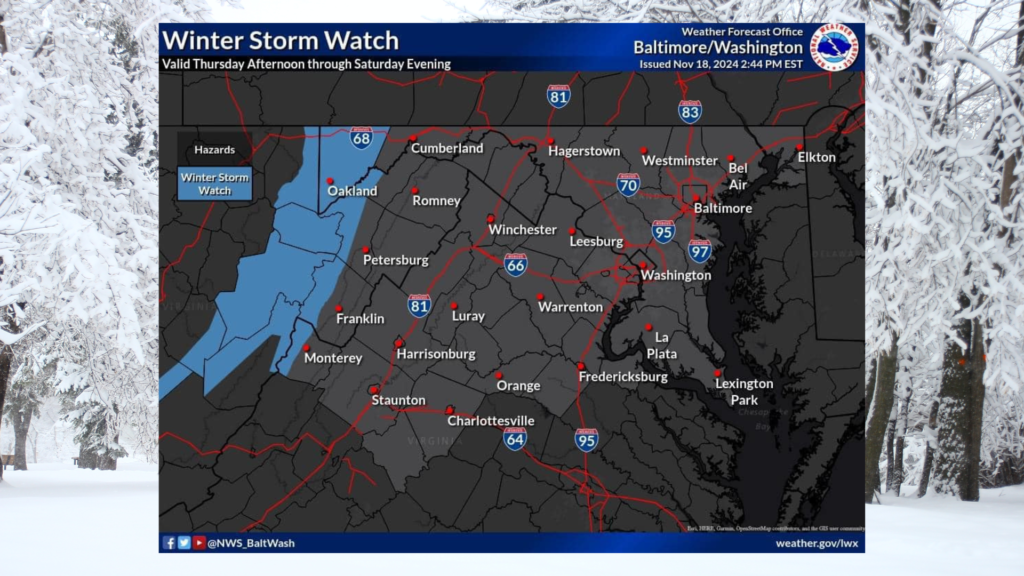
The first widespread snowfall of the season is expected for the Allegheny Mountains Thursday afternoon through Saturday evening.
A Winter Storm Watch is in effect where snow accumulations >6″ are possible.
Continue to monitor Garrett County OEM / 911 Communications for the latest information.
OVERVIEW:
A strong weather system will move near the Great Lakes later this week, bringing notably colder temperatures. This will likely lead to the first widespread accumulating snowfall of the season across the Allegheny Mountains.
TIMING:
- Thursday through early Saturday.
- Most intense snowfall late Thursday night into Friday.
HAZARDS & IMPACTS:
There is an enhanced winter storm threat Thursday through Friday night, with a slight winter storm threat continuing into early Saturday due to the potential for several days of accumulating upslope snowfall. Gusty winds could lead to blowing and drifting snow, as well as downed trees that could lead to power outages. If this threat materializes, significant travel disruptions are possible.
FORECAST CONFIDENCE:
Confidence in start time is medium. Timing of most intense snowfall still low confidence, but coming into better focus. Snow is likely, with low confidence on exact amounts. Monitor weather.gov/lwx/wintermaps for the latest updates.
Resources From the Garrett County Health Department:
Emergency Preparedness Tips – Cold Weather Preparedness:
(https://garretthealth.org/emergency-preparedness-tips-cold-weather-preparedness/)

Contact: [email protected]
- Weather-Related Cancelation – Bounce Into Summer Event - June 8, 2025
- 360 Access Hub (Also Known as the Garrett County Food Bank Project) Takes Another Step Forward With Help From Community Works Garrett County! - June 6, 2025
- Garrett County Enhances Stakeholder Access to Advanced Mapping Tools and Public Property Records Through a Strategic Collaboration Between the Health Department and Garrett County Government - June 6, 2025